About 7 hours total time
Overall 5:37 moving time at heart rate 140 (73% max), 5100' climb/descent, about 17.5 miles
Hiking: 2:55, 4225' climb, 125' descent, HR 139, about 5.9 miles
Running: 2:53, 875' climb, 4925' descent, HR 141, about 11.6 miles
Basically most of it is very technical, and I ran where I could. Most of the uphills were too steep to run. Interesting (to me) how similar the heart rates are.
Gear: I chose the Saucony Peregrines, a lighter shoe, over the Montrails, and it worked out really good. My feet were comfortable the whole time and they handled the miles of rubble fine. I'd brought a very thin shell top, my headlamp, fire starting stuff, about 1000 Cal of food, and a little over a gallon of water. But I ran out of water with about 2 miles to go, and I'd run out of food before that. All the springs were dry on the main loop. Good thing it wasn't a hot day!
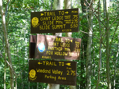
Trail to Wittenburg
Somewhere in here, about a third of the way up Wittenburg, I passed a group of a dozen mid-teenage backpackers. I didn't see anybody else until I got the col between Cornell and Slide.
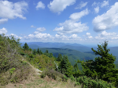
Views from Wittenburg, South
East, the Ashoken Res, at least half a vertical mile below, very low water, huge sandbars visible
North, the Devil's path range
North, looking back at Wittenburg from Cornell
Camping spot atop Cornell
West from Cornell, Slide Mountain looming
South, a glimpse of Rocky and Table mountains
In the col before Slide, I saw a couple of backpackers looking at the camping spots there (some nice ones). Then I met a solo backpacker heading down the steep side of Slide. He was looking for water but said the spring higher up was dry. The trail was really wet after lots of thunderstorms in this area (rocks really slippery, wet feet a bit) but the rains have been quick so we're starting to get drought conditions in some areas even though everything is lush on the surface. I told the guy that he might have to hunt south off the col for streams that become the headwaters of the Neversink river (east branch). I did that once when overnight-ing off-trail, just keep going downhill in the deepest gully you can find until water is flowing. Costly in terms of contours though, and not guaranteed.
The rubble trail down from Cornell
Lots of very tough ledges between Cornell and Slide, many being more dangerous than anything on the Escarpment trail
The steep side of Slide has some small cliffs you have to climb, and a bunch of ladders
East, Wittenburg and Cornell from the slopes of Slide
Top of Slide, All the good views are a bit down the hill
Up on top of Slide I started to see more people, four people on top already when I got there, then about half a dozen more on the descent to the main Slide parking area.
Heading down Slide to the west there is one great view to the north, this one looks down at Giant Ledge, where I'm headed next, and Panther mountain beyond
Giant Ledge doesn't look like much from here, but it probably has the best easy-hike (from rt 47) views in the Catskills
North still, Devil's path range again
Heading west, the trail on top of Slide is fairly runnable at first
Then it descends into worse and worse rubble, quite challenging stuff lower down
Midway down, what does that look like 15%? Nasty rubble
Camera held level, looking down the trail
Same, looking up
9.7 miles to go.
Had to do a mile (?) on the road
The Winnisook lodge private club in the saddle of the hill at 2700'
Just past the lake, where the road heads downhill is the easement, but the marked trail follows the road. Of course I took the easement, to save a whole bunch of contour lines.
Looks like the Winnisook lodge wanted a nice level trail over to Giant Ledge, but 95% of it is on public land, so I guess the compromise was it's fine for the public to use it (hence the easement over the short bit at the start), but in every other way discourage the public from using it, making the marked trail detour 700 vertical feet down to the road and put up sticks and stuff to discourage people.
About to detour 1.5 miles for the views at Giant Ledge
Which are here: North
Southeast, the ridge around the Woodland valley basin I climbed and hiked/ran around
The trail back down to Woodland valley is full of rubble and is very technical because of that, but this photo doesn't really show it, oh well.
Halfway down the 2.7 miles to Woodland valley I saw the same group of teenagers I'd seen 6 hours earlier, now going uphill when I was coming down. They were kind of shocked I'd come all the way around when they'd only gone about 2 1/2 miles, and that I was running down the trail, which was full of nasty rubble (basically almost no dirt and several levels of smaller unstable rocks). I thought at the time: backpacking is fun sometimes but I'm happy to be heading home.
After I saw those disheartened kids (they had a good 1200' to climb, preferably before dark and it was already almost 6pm, that side of the valley already in shadow), the one group higher up waiting for 3 girls dragging far behind -- I was happily scooting down the rocks as efficiently as I could, and then the trail suddenly turns left at the bottom of a huge reentrant, and starts going straight back up the mountain at a 40 to 45 degree slope, the trail markers stretching on up the hill out of sight. Ok I'm thinking, I was having fun cruising, what the hell?! That got me to get the map out, so checking, I see the big square corner of private land jutting deep into the park from the valley road. Got it. But, you know, I'd been out of water for 45 minutes by then, with still a tough 1.x to go, so I didn't relish climbing those 250 vertical feet just then, but that's the trail. Somehow I'd forgotten that little bit after I last did this stretch of trail almost 20 years ago. Oh I was going the other way, that's why.
Done
I changed the total length estimate to 17.5 miles. The 16 miles the trail map specifies for the whole loop, + the 1.5 mile GL detour, - 0.5 the savings of the easement, + 0.5, the little bit running down the wrong trail (cruising having a good time); well someone had stolen the trail markers at the turn.
Not that miles really matter much on these kind of trails. I just look at the map and based on experience and some knowledge of the terrain make an educated guess on how long the whole thing will take me. This time I had guessed I could do it in about 5 hours moving time, running and hiking. I always like to stop for 5 minutes here, 10 minutes there, and always longer at some point. So the overall time was 7 hours, more important to me is moving time. So this time was 5:47 moving time, about evenly divided between hiking and running. No leisurely hiking this time, just pushing steadily up 4k+ of climb. Not having done some of these trails in 20 years I'd forgotten how technical the footing is and the rocks were really wet in many places, so I wasn't taking chances.
I never ran this loop before, but hiked it 19 years ago, and have run various little parts of it since then. "Running" this loop intimidated me a little in the past. I would do pretty big stuff (for me) in the Catskills, like a 27 mile loop on all new (but easier) trails to me over near Mongaup pond, but I didn't think of running this Slide loop until a few days before. I think the difference now is how much more hiking I've been doing this year as I've extended my outings that used to be pretty much all trail runs. Now I go out with the intent to hike part of the time and run part of the time, and that gives me confidence to not only handle a bit longer stuff on a daily basis, but a go-as-you-please approach makes the outing more enjoyable. In this case though I did run everything I could; the terrain dictated that I hike fully half of it time-wise, one third by mileage.


I need to hike here! (someday...)
ReplyDelete